Click below to agree to the terms of use.
By clicking the I accept button at the bottom of this page, or by otherwise using the National Land Realty, LLC (“NLR”) website and accessing any content, you agree to be bound by the following terms of use, as updated from time to time (“Terms of Use”).
- Disclaimer about Information Provided. Maps available through this website contain representations of land features compiled from aerial photography, remote sensing technology, recorded deeds and plats, other public records and public data. Users of these maps are hereby notified that the aforementioned public primary information sources should be consulted for verification of the information contained in these maps. These maps are NOT A LAND SURVEY. National Land Realty, LLC, does not warrant the accuracy, reliability or timeliness of any information on this website, including, without limitation, any information relating to any prior sales of any real property, specifically including the purchase price. Portions of such information may be incorrect or not current. Any personal entity that relies on any information obtained from this website does so at his or her own risk. National Land Realty, LLC, hereby disclaims any and all liability arising from the information provided on this website. Any person or entity relying on information from this site does so at their own risk.
- Prohibited Uses. BY USING THE NLR WEBSITE, YOU AGREE NOT TO:
- reproduce, modify, distribute, display or otherwise provide access to, create derivative works from, decompile, disassemble, or reverse engineer any portion of the website or the services provided by the website, except as explicitly permitted under these Terms of Use;
- reproduce, publicly display, or otherwise make accessible on or through any other website, application, or service any reviews, ratings, and/or profile information about real estate, lending, or other professionals, underlying images of or information about real estate listings, or other data or content available through the NLR website, except as explicitly permitted by NLR;
- conduct automated queries (including screen and database scraping, spiders, robots, crawlers, bypassing “captcha” or similar precautions, and any other automated activity with the purpose of obtaining information from the NLR website) on the NLR website;
- Indemnification. You agree to indemnify, defend, and hold harmless NLR, its affiliates, and their respective directors, officers, employees, and agents from any and all claims and demands made by any third party due to or arising out of: (a) your access to or use of the NLR website; (b) your breach of these Terms of Use; (c) your violation of any law or the rights of a third party; (d) any dispute or issue between you and any third party; and (e) your willful misconduct. NLR reserves the right, at its own expense, to assume the exclusive defense and control of any matter otherwise subject to indemnification by you, and in that case, you agree to cooperate with NLR’s defense of that claim.
- No Warranties. THE SERVICES AND INFORMATION PROVIDED ON NLR’S WEBSITE ARE PROVIDED "AS IS," "WITH ALL FAULTS" AND "AS AVAILABLE," AND THE ENTIRE RISK AS TO SATISFACTORY QUALITY, PERFORMANCE, ACCURACY, AND EFFORT IS WITH YOU. TO THE MAXIMUM EXTENT PERMITTED BY APPLICABLE LAW, NLR AND ITS SUPPLIERS MAKE NO REPRESENTATIONS, WARRANTIES OR CONDITIONS, EXPRESS OR IMPLIED. NLR AND ITS SUPPLIERS EXPRESSLY DISCLAIM ANY AND ALL WARRANTIES OR CONDITIONS, EXPRESS, STATUTORY AND IMPLIED. NO ADVICE OR INFORMATION, WHETHER ORAL OR WRITTEN, OBTAINED BY YOU THROUGH THE NLR WEBSITE OR ANY MATERIALS AVAILABLE THROUGH THE NLR WEBSITE WILL CREATE ANY WARRANTY REGARDING ANY NLR ENTITY OR THE NLR WEBSITE THAT IS NOT EXPRESSIVELY STATED IN THESE TERMS OF USE. YOU ASSUME ALL RISK FOR ANY DAMAGE THAT MAY RESULT FROM YOUR USE OF OR ACCESS TO THE NLR WEBSITE, AND ANY MATERIALS, INCLUDING ALL NLR MATERIALS, AVAILABLE THROUGH THE NLR WEBSITE. YOU UNDERSTAND AND AGREE THAT YOUR USE OF THE NLR WEBSITE, AND USE, ACCESS, DOWNLOAD, OR OTHERWISE OBTAINMENT OF MATERIALS THROUGH THE NLR WEBSITE, ARE AT YOUR OWN DISCRETION AND RISK, AND THAT YOU ARE SOLELY RESPONSIBLE FOR ANY DAMAGE TO YOUR PROPERTY (INCLUDING YOUR COMPUTER SYSTEM OR MOBILE DEVICE USED IN CONNECTION WITH THE NLR WEBSITE), OR THE LOSS OF DATA THAT RESULTS FROM THE USE OF THE NLR WEBSITE. SOME JURISDICTIONS MAY PROHIBIT A DISCLAIMER OR WARRANTIES AND YOU MAY HAVE OTHER RIGHTS THAT VARY FROM JURISDICTION TO JURISDICTION.


Why You'll Love It
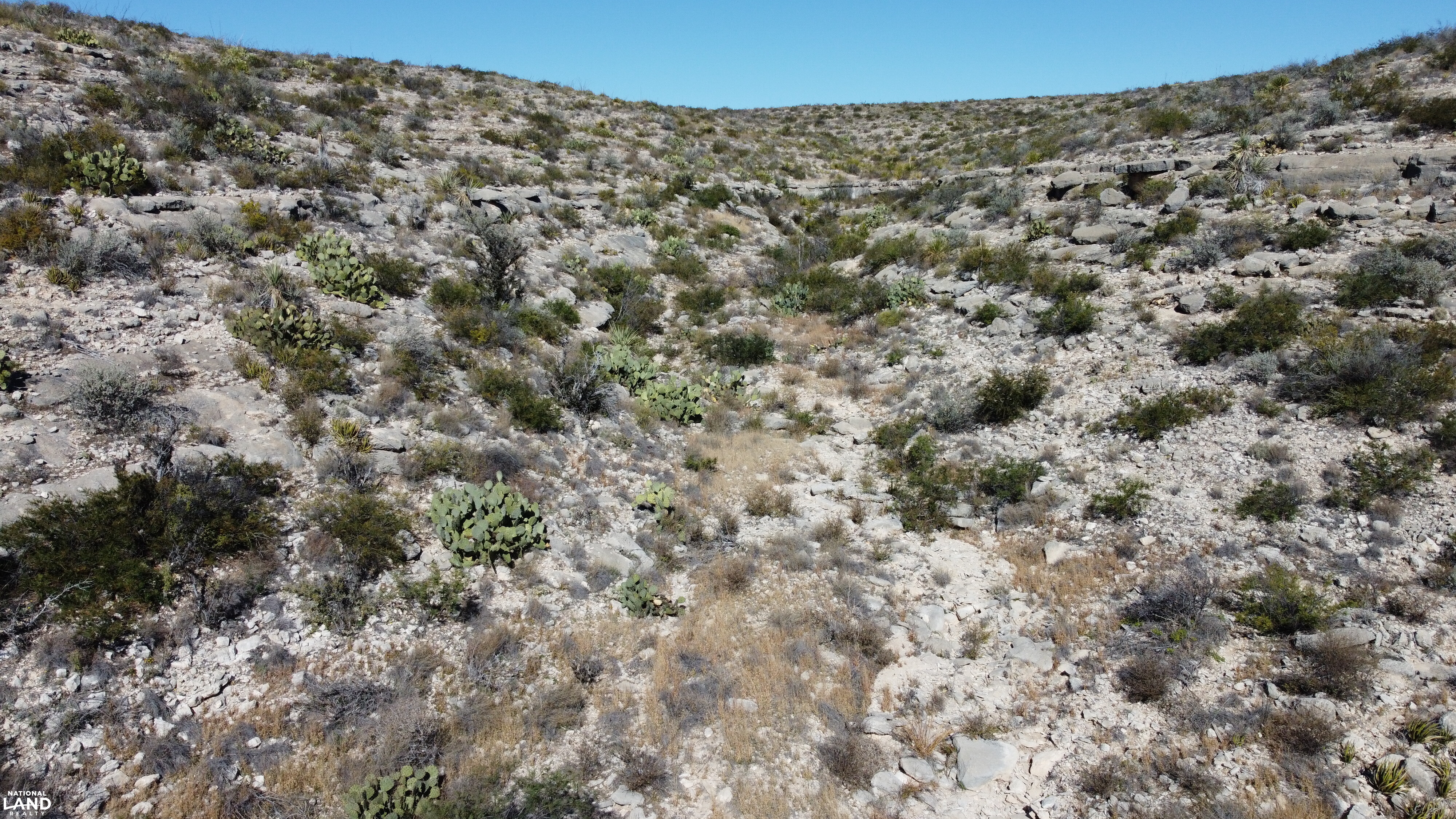
Water's Big Canyon ranch is +/- 236 acres of some of the most picturesque and remote country that can be found in the Trans Pecos region of Texas! The flat country to the north gives way to dramatic canyons that wind their way south towards the Rio Grande! The stunning views to the south reveal the towering mountains of Mexico! Dominant brush in this area serve the wildlife well and include Cenizo, Mesquite, Sotol, Gaujillo, Guayacan, and Ocotillo, and Creosote. These plants are extremely well adapted to the area and drought tolerant. The only thing more rugged than the terrain are the animals that call this region home. Current owners have managed for trophy Mule Deer for decades! Aoudad or Barbary Sheep also thrive in these steep canyons and provide for year-round hunting! If summer fishing is your preference, owning land in Sanderson River Ranch POA affords you access to property along the Rio Grande River. Along with river access, the association also offers access to a community water well and there's a water line just north of these tracts. This ranch packs a punch for its size and it will be hard to find another one more remote!
Parcel #/ID
16141, 16142
Legal Information
Lots 13A & 13B, Sanderson River Ranch Subdivision, Terrell County, TX, as shown by the plat of record in Volume 1, Page 22, Plat Records of Terrell County, Texas, Which amended the map or plat of said Sanderson River Ranch Subdivision, of record in Volume 110, Page 365, Deed Records, Terrell County Texas
Property Highlights
| Farms & Ranches | Ranchland, Range/Pasture |
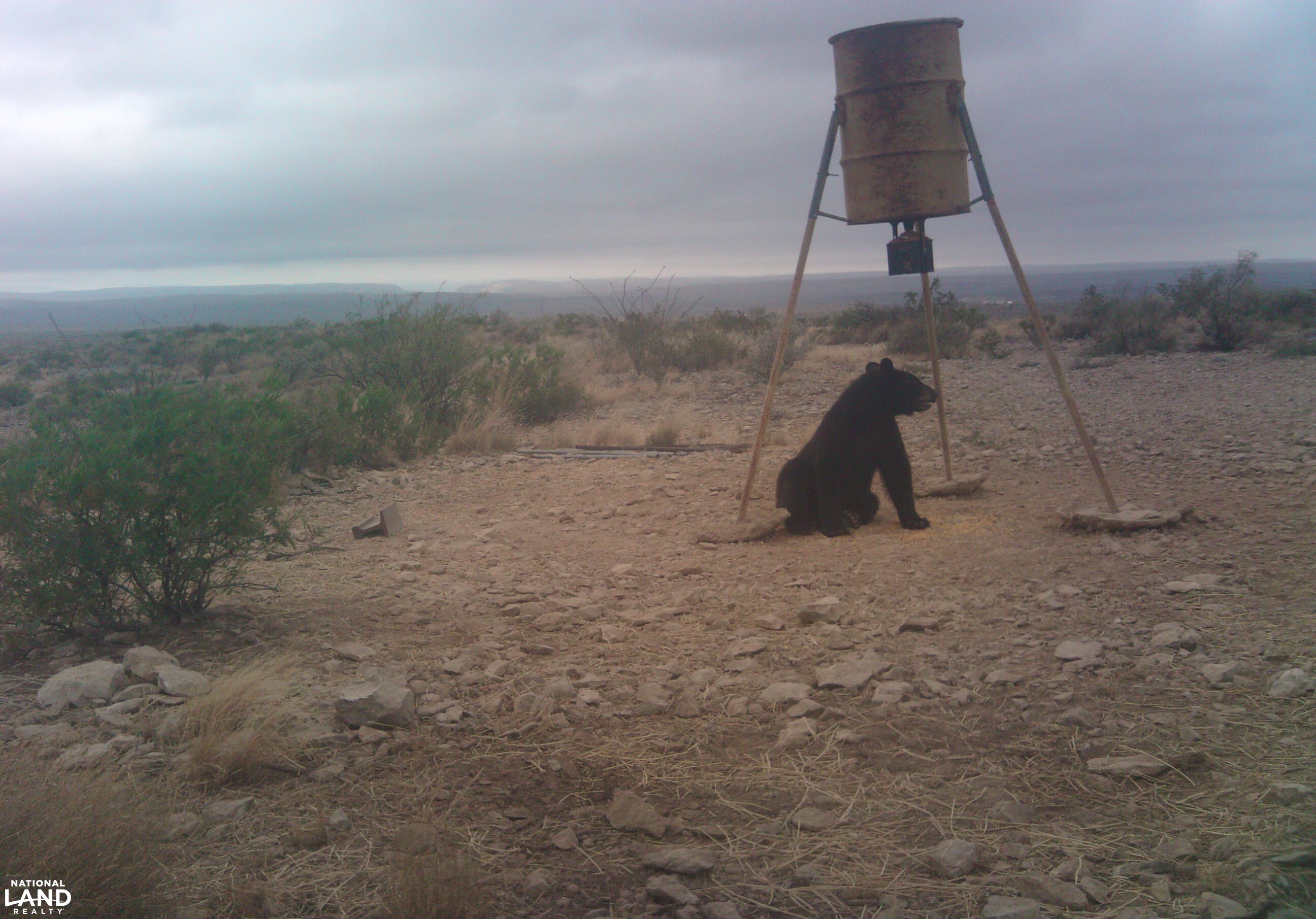
| Hunting, Fishing & Recreation | Fishing, River/Creek/Stream, ATVing, Camping, Hiking, Mule Deer, Bear, Silent Sports/Nature |
| Homes, Cabins, Acreages & Lots | Vacant Land |
- Sanderson River Ranch Property Owner's Association helps with road maintenance
- The POA offers community water wells with poly lines for distribution
- There's a community water line just north of this property that can be tapped for use
- Sanderson River Ranch Property Owner's Association offers a community tract of land along the Rio Grande that can be used for river access if fishing or water recreation is on your agenda. Access is 7.2 miles from this ranch!
- Combination locked gate to enter the area by this property
- Easement access appears to be well maintained all the way from the highway
- Scenic views like you won't find anywhere else!
- Deep canyons with flat topped ridges which allow for game travel corridors
- Mule Deer Hunting
- Aoudad (Barbary Sheep) Hunting
- Javelina call this area home
- Plenty of predatory animals including coyote and bobcats
- If you are lucky, you might see one of the protected Black Bears that call this region home!
- Remote and rugged land where you won't here the sounds of traffic. This area is far removed from civilization
2023 Taxes:
$54
Zoning:
None
Future Land Use:
Recreational or Hunting Use
Listing ID#:
2788102
Location
29.914995589035 , -102.32003091894
Head east from Sanderson on Highway 90. Take 5 Mile Road south off Highway 90 for 2.2 miles turn left of Bone Water Road. Go 1 mile to "horshoe gate" which is key locked. Then go 3.8 miles take a right at the fork with the sign reading Coots, Cravens, McMahon, Vines, Winborn. Go 1.9 miles & stay straight at the Danica Drive cattle guard and sign. Proceed 1.1 miles to Sanderson River Ranch sign and continue straight. Continue 2.3 miles and go right at the fork. Road dead ends at combination gate. Keep going 1.4 miles and go straight at the fork. Another 1.7 miles and turn left. You'll pass through an old fence and the property starts just past that gap. The property is approximately 15 miles south of the highway


Land by State
Land Professionals by State
- Alabama
- Arizona
- Arkansas
- California
- Colorado
- Delaware
- Florida
- Georgia
- Idaho
- Illinois
- Indiana
- Iowa
- Kansas
- Kentucky
- Louisiana
- Maryland
- Massachusetts
- Minnesota
- Mississippi
- Missouri
- Nebraska
- Nevada
- New Mexico
- North Carolina
- North Dakota
- Ohio
- Oklahoma
- Oregon
- Pennsylvania
- South Carolina
- South Dakota
- Tennessee
- Texas
- Utah
- Vermont
- Virginia
- West Virginia
- Wisconsin
- Alabama
- Arizona
- Arkansas
- California
- Colorado
- Delaware
- District of Columbia
- Florida
- Georgia
- Idaho
- Illinois
- Indiana
- Iowa
- Kansas
- Kentucky
- Louisiana
- Maryland
- Massachusetts
- Michigan
- Minnesota
- Mississippi
- Missouri
- Montana
- Nebraska
- Nevada
- New Jersey
- New Mexico
- New York
- North Carolina
- North Dakota
- Ohio
- Oklahoma
- Oregon
- Pennsylvania
- South Carolina
- South Dakota
- Tennessee
- Texas
- Utah
- Vermont
- Virginia
- Washington
- West Virginia
- Wisconsin
- Wyoming