Click below to agree to the terms of use.
By clicking the I accept button at the bottom of this page, or by otherwise using the National Land Realty, LLC (“NLR”) website and accessing any content, you agree to be bound by the following terms of use, as updated from time to time (“Terms of Use”).
- Disclaimer about Information Provided. Maps available through this website contain representations of land features compiled from aerial photography, remote sensing technology, recorded deeds and plats, other public records and public data. Users of these maps are hereby notified that the aforementioned public primary information sources should be consulted for verification of the information contained in these maps. These maps are NOT A LAND SURVEY. National Land Realty, LLC, does not warrant the accuracy, reliability or timeliness of any information on this website, including, without limitation, any information relating to any prior sales of any real property, specifically including the purchase price. Portions of such information may be incorrect or not current. Any personal entity that relies on any information obtained from this website does so at his or her own risk. National Land Realty, LLC, hereby disclaims any and all liability arising from the information provided on this website. Any person or entity relying on information from this site does so at their own risk.
- Prohibited Uses. BY USING THE NLR WEBSITE, YOU AGREE NOT TO:
- reproduce, modify, distribute, display or otherwise provide access to, create derivative works from, decompile, disassemble, or reverse engineer any portion of the website or the services provided by the website, except as explicitly permitted under these Terms of Use;
- reproduce, publicly display, or otherwise make accessible on or through any other website, application, or service any reviews, ratings, and/or profile information about real estate, lending, or other professionals, underlying images of or information about real estate listings, or other data or content available through the NLR website, except as explicitly permitted by NLR;
- conduct automated queries (including screen and database scraping, spiders, robots, crawlers, bypassing “captcha” or similar precautions, and any other automated activity with the purpose of obtaining information from the NLR website) on the NLR website;
- Indemnification. You agree to indemnify, defend, and hold harmless NLR, its affiliates, and their respective directors, officers, employees, and agents from any and all claims and demands made by any third party due to or arising out of: (a) your access to or use of the NLR website; (b) your breach of these Terms of Use; (c) your violation of any law or the rights of a third party; (d) any dispute or issue between you and any third party; and (e) your willful misconduct. NLR reserves the right, at its own expense, to assume the exclusive defense and control of any matter otherwise subject to indemnification by you, and in that case, you agree to cooperate with NLR’s defense of that claim.
- No Warranties. THE SERVICES AND INFORMATION PROVIDED ON NLR’S WEBSITE ARE PROVIDED "AS IS," "WITH ALL FAULTS" AND "AS AVAILABLE," AND THE ENTIRE RISK AS TO SATISFACTORY QUALITY, PERFORMANCE, ACCURACY, AND EFFORT IS WITH YOU. TO THE MAXIMUM EXTENT PERMITTED BY APPLICABLE LAW, NLR AND ITS SUPPLIERS MAKE NO REPRESENTATIONS, WARRANTIES OR CONDITIONS, EXPRESS OR IMPLIED. NLR AND ITS SUPPLIERS EXPRESSLY DISCLAIM ANY AND ALL WARRANTIES OR CONDITIONS, EXPRESS, STATUTORY AND IMPLIED. NO ADVICE OR INFORMATION, WHETHER ORAL OR WRITTEN, OBTAINED BY YOU THROUGH THE NLR WEBSITE OR ANY MATERIALS AVAILABLE THROUGH THE NLR WEBSITE WILL CREATE ANY WARRANTY REGARDING ANY NLR ENTITY OR THE NLR WEBSITE THAT IS NOT EXPRESSIVELY STATED IN THESE TERMS OF USE. YOU ASSUME ALL RISK FOR ANY DAMAGE THAT MAY RESULT FROM YOUR USE OF OR ACCESS TO THE NLR WEBSITE, AND ANY MATERIALS, INCLUDING ALL NLR MATERIALS, AVAILABLE THROUGH THE NLR WEBSITE. YOU UNDERSTAND AND AGREE THAT YOUR USE OF THE NLR WEBSITE, AND USE, ACCESS, DOWNLOAD, OR OTHERWISE OBTAINMENT OF MATERIALS THROUGH THE NLR WEBSITE, ARE AT YOUR OWN DISCRETION AND RISK, AND THAT YOU ARE SOLELY RESPONSIBLE FOR ANY DAMAGE TO YOUR PROPERTY (INCLUDING YOUR COMPUTER SYSTEM OR MOBILE DEVICE USED IN CONNECTION WITH THE NLR WEBSITE), OR THE LOSS OF DATA THAT RESULTS FROM THE USE OF THE NLR WEBSITE. SOME JURISDICTIONS MAY PROHIBIT A DISCLAIMER OR WARRANTIES AND YOU MAY HAVE OTHER RIGHTS THAT VARY FROM JURISDICTION TO JURISDICTION.

Why You'll Love It
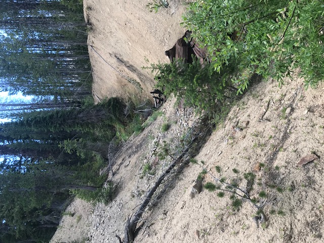
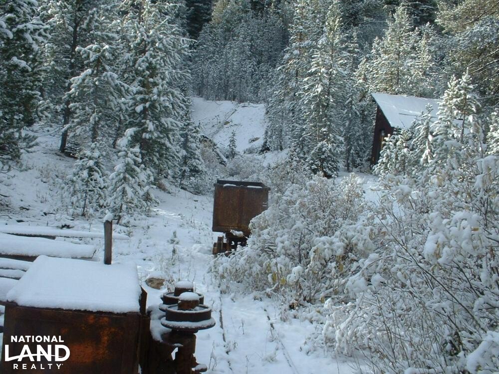
This unique property is 145.54 acres has been owned by the same family for more than 120 years. The property is a privately held land parcel surrounded by BLM land on all sides. The Patented Mining Claim is for approximately 140 acres and also includes Patented Mill site on the property. There is abundant wildlife in the area passing through the property. This is an alpine setting with a year round creek flowing through a large meadow on the property. Most of the property is located 7,000 feet above sea level. For hunting there are thousands of acres of adjoining BLM land surrounding the property. The area is also a popular snow mobile riding area with groomed trails nearby. Mining operations for the once active Mammoth Mine were suspended in the 1930's due to gold ownership restrictions. The property is accessed by Summit Flat Road from ID 21 approximately six miles to the south.
Please contact Agent for any additional information concerning Property.
Parcel #/ID
P08N06E260034 and RP08N06E26E250045
Legal Information
Legal Description- Mammoth Group LLC Properties:
RP08N06E260045 - 140.57 +/- acres – T8N R6E SEC PAT MIN 3581, MILLSITE 3591
RP08N06E250045 - 4.97 +/- acres - T8N RGE SEC 25 PAT MIN 3581
Unit Size:
6,426,842 SF
Property Highlights
| Hunting, Fishing & Recreation | Upland Game, Waterfowl, Turkey, Equestrian, River/Creek/Stream, ATVing, Camping, Elk, Hiking, Mule Deer, RV-Friendly, Bear, Snowmobiling, Fishing |
| Timberland Investment | Hardwood |
| Homes, Cabins, Acreages & Lots | Vacant Land |
| Energy & Natural Resources | Water Rights, Mining |
- The property is surrounded by National Forest Service land on all sides. It is an alpine location that experienced a fire in 2016 that burned some of the timber north of the mine. There is abundant water on the property with several varieties of waterfowl migrating through the area. Grimes Creek flows year round through the property.
- This property has significant wildlife passing through the property including elk, mule deer, bears and bobcats. There is hunting on the property and through out the BLM land surrounding the property. Winter activities for this area of Boise County are focused on Snow Mobile trails that are groomed during the high activity months. During the summer months ATV activity is extensive in this mountainous region of Idaho.
- The dominate activity on the property was mining. This occurred from the early 1850's to 1933. Idaho City was the prominent community in the area with more than 20,000 people living there during the height of gold activities for Boise County. The population for Idaho City today is approximately 450 people.
- Mammoth mine is well known in Idaho and was a productive mine for placer gold in the Idaho City mining community until the government declared that individuals could not own gold as of May 1, 1933. Before that an estimated $650,000 in gold had been taken from the Mammoth claim. At the then current price of $20.67 per ounce this represented approximately 31,500 ounces of gold ore. According to the owners the ore was some of the highest grade ore found in Idaho. At today's current price at approximately $1750 per ounce the gold removed would be worth more than $50 million. If you desire more information concerning this unique property, please contact the agent, Todd Walter at Twalter@nationalland.com
- From the reports made by the owner in 1933 when mining operation were suspended there should be significant gold ore deeper than mining operations went then due to water infiltration in the mine shaft that can be easily dealt with by current mining technology. There are additional veins off from the main mine shaft where significant ore deposits are suspected but never mined.
- There is an assay report taken in 2007 of the tailing deposits above ground. This assay reports are available to prospective buyers of the Mammoth Group, LLC property.
- This property and rights to specific BLM lands represent an island in the Boise National Forest. There still remain deposits of gold and silver most likely below the 200 foot level where flooding occur in the 1930's and possibly in another vein not excavated with in the Patented Claims known as Fourth of July, Fourth of July No. 2 and Fourth of July No. 3.
Estimated Acres:
145.54 +/- acres of land. There are 145.55 acres of Patented and unpatented Claim Land of which 140.572 acres are Patented Claim and 4.978 acres are for Patented Mill Site. Also, the owners are selling all their rights to 100 +/- acres of unpatented BLM land that is adjacent to the property.
2020 Taxes:
$663
Listing ID#:
2772617
Location
44.002451693233 , -115.71268154819
Summit Flat Road is approximately 19 miles on ID 21 traveling north from Idaho City. Make a Left turn onto Summit Flat Road from ID 21. The Mammoth Mine property is approximately 6 miles from ID 21. Or, also from Idaho City and less mountainous, take Centreville Road north, at Grimes Creek Road turn right. Follow Grimes Creek Road to Summit Flat Road turn right and follow Summit Creek Road until you reach the Mammoth Mine meadow on the right continue to the entrance and bridge over Grimes Creek.


Land by State
Land Professionals by State
- Alabama
- Arizona
- Arkansas
- California
- Colorado
- Delaware
- Florida
- Georgia
- Idaho
- Illinois
- Indiana
- Iowa
- Kansas
- Kentucky
- Louisiana
- Maryland
- Massachusetts
- Minnesota
- Mississippi
- Missouri
- Nebraska
- Nevada
- New Mexico
- North Carolina
- North Dakota
- Ohio
- Oklahoma
- Oregon
- Pennsylvania
- South Carolina
- South Dakota
- Tennessee
- Texas
- Utah
- Vermont
- Virginia
- West Virginia
- Wisconsin
- Alabama
- Arizona
- Arkansas
- California
- Colorado
- Delaware
- District of Columbia
- Florida
- Georgia
- Idaho
- Illinois
- Indiana
- Iowa
- Kansas
- Kentucky
- Louisiana
- Maryland
- Massachusetts
- Michigan
- Minnesota
- Mississippi
- Missouri
- Montana
- Nebraska
- Nevada
- New Jersey
- New Mexico
- New York
- North Carolina
- North Dakota
- Ohio
- Oklahoma
- Oregon
- Pennsylvania
- South Carolina
- South Dakota
- Tennessee
- Texas
- Utah
- Vermont
- Virginia
- Washington
- West Virginia
- Wisconsin
- Wyoming