Click below to agree to the terms of use.
By clicking the I accept button at the bottom of this page, or by otherwise using the National Land Realty, LLC (“NLR”) website and accessing any content, you agree to be bound by the following terms of use, as updated from time to time (“Terms of Use”).
- Disclaimer about Information Provided. Maps available through this website contain representations of land features compiled from aerial photography, remote sensing technology, recorded deeds and plats, other public records and public data. Users of these maps are hereby notified that the aforementioned public primary information sources should be consulted for verification of the information contained in these maps. These maps are NOT A LAND SURVEY. National Land Realty, LLC, does not warrant the accuracy, reliability or timeliness of any information on this website, including, without limitation, any information relating to any prior sales of any real property, specifically including the purchase price. Portions of such information may be incorrect or not current. Any personal entity that relies on any information obtained from this website does so at his or her own risk. National Land Realty, LLC, hereby disclaims any and all liability arising from the information provided on this website. Any person or entity relying on information from this site does so at their own risk.
- Prohibited Uses. BY USING THE NLR WEBSITE, YOU AGREE NOT TO:
- reproduce, modify, distribute, display or otherwise provide access to, create derivative works from, decompile, disassemble, or reverse engineer any portion of the website or the services provided by the website, except as explicitly permitted under these Terms of Use;
- reproduce, publicly display, or otherwise make accessible on or through any other website, application, or service any reviews, ratings, and/or profile information about real estate, lending, or other professionals, underlying images of or information about real estate listings, or other data or content available through the NLR website, except as explicitly permitted by NLR;
- conduct automated queries (including screen and database scraping, spiders, robots, crawlers, bypassing “captcha” or similar precautions, and any other automated activity with the purpose of obtaining information from the NLR website) on the NLR website;
- Indemnification. You agree to indemnify, defend, and hold harmless NLR, its affiliates, and their respective directors, officers, employees, and agents from any and all claims and demands made by any third party due to or arising out of: (a) your access to or use of the NLR website; (b) your breach of these Terms of Use; (c) your violation of any law or the rights of a third party; (d) any dispute or issue between you and any third party; and (e) your willful misconduct. NLR reserves the right, at its own expense, to assume the exclusive defense and control of any matter otherwise subject to indemnification by you, and in that case, you agree to cooperate with NLR’s defense of that claim.
- No Warranties. THE SERVICES AND INFORMATION PROVIDED ON NLR’S WEBSITE ARE PROVIDED "AS IS," "WITH ALL FAULTS" AND "AS AVAILABLE," AND THE ENTIRE RISK AS TO SATISFACTORY QUALITY, PERFORMANCE, ACCURACY, AND EFFORT IS WITH YOU. TO THE MAXIMUM EXTENT PERMITTED BY APPLICABLE LAW, NLR AND ITS SUPPLIERS MAKE NO REPRESENTATIONS, WARRANTIES OR CONDITIONS, EXPRESS OR IMPLIED. NLR AND ITS SUPPLIERS EXPRESSLY DISCLAIM ANY AND ALL WARRANTIES OR CONDITIONS, EXPRESS, STATUTORY AND IMPLIED. NO ADVICE OR INFORMATION, WHETHER ORAL OR WRITTEN, OBTAINED BY YOU THROUGH THE NLR WEBSITE OR ANY MATERIALS AVAILABLE THROUGH THE NLR WEBSITE WILL CREATE ANY WARRANTY REGARDING ANY NLR ENTITY OR THE NLR WEBSITE THAT IS NOT EXPRESSIVELY STATED IN THESE TERMS OF USE. YOU ASSUME ALL RISK FOR ANY DAMAGE THAT MAY RESULT FROM YOUR USE OF OR ACCESS TO THE NLR WEBSITE, AND ANY MATERIALS, INCLUDING ALL NLR MATERIALS, AVAILABLE THROUGH THE NLR WEBSITE. YOU UNDERSTAND AND AGREE THAT YOUR USE OF THE NLR WEBSITE, AND USE, ACCESS, DOWNLOAD, OR OTHERWISE OBTAINMENT OF MATERIALS THROUGH THE NLR WEBSITE, ARE AT YOUR OWN DISCRETION AND RISK, AND THAT YOU ARE SOLELY RESPONSIBLE FOR ANY DAMAGE TO YOUR PROPERTY (INCLUDING YOUR COMPUTER SYSTEM OR MOBILE DEVICE USED IN CONNECTION WITH THE NLR WEBSITE), OR THE LOSS OF DATA THAT RESULTS FROM THE USE OF THE NLR WEBSITE. SOME JURISDICTIONS MAY PROHIBIT A DISCLAIMER OR WARRANTIES AND YOU MAY HAVE OTHER RIGHTS THAT VARY FROM JURISDICTION TO JURISDICTION.
Why You'll Love It
All upland game and waterfowl hunting land. Deer, Turkey, Ducks, Bear, Bobcat, Opossum, Racoon, ... as far as we know, this massive swamp has not had a human foot on it since at least 2004 (Last time I was there), even this week flying the drone you will see that we did not go in and disturb any of the wildlife nurseries.
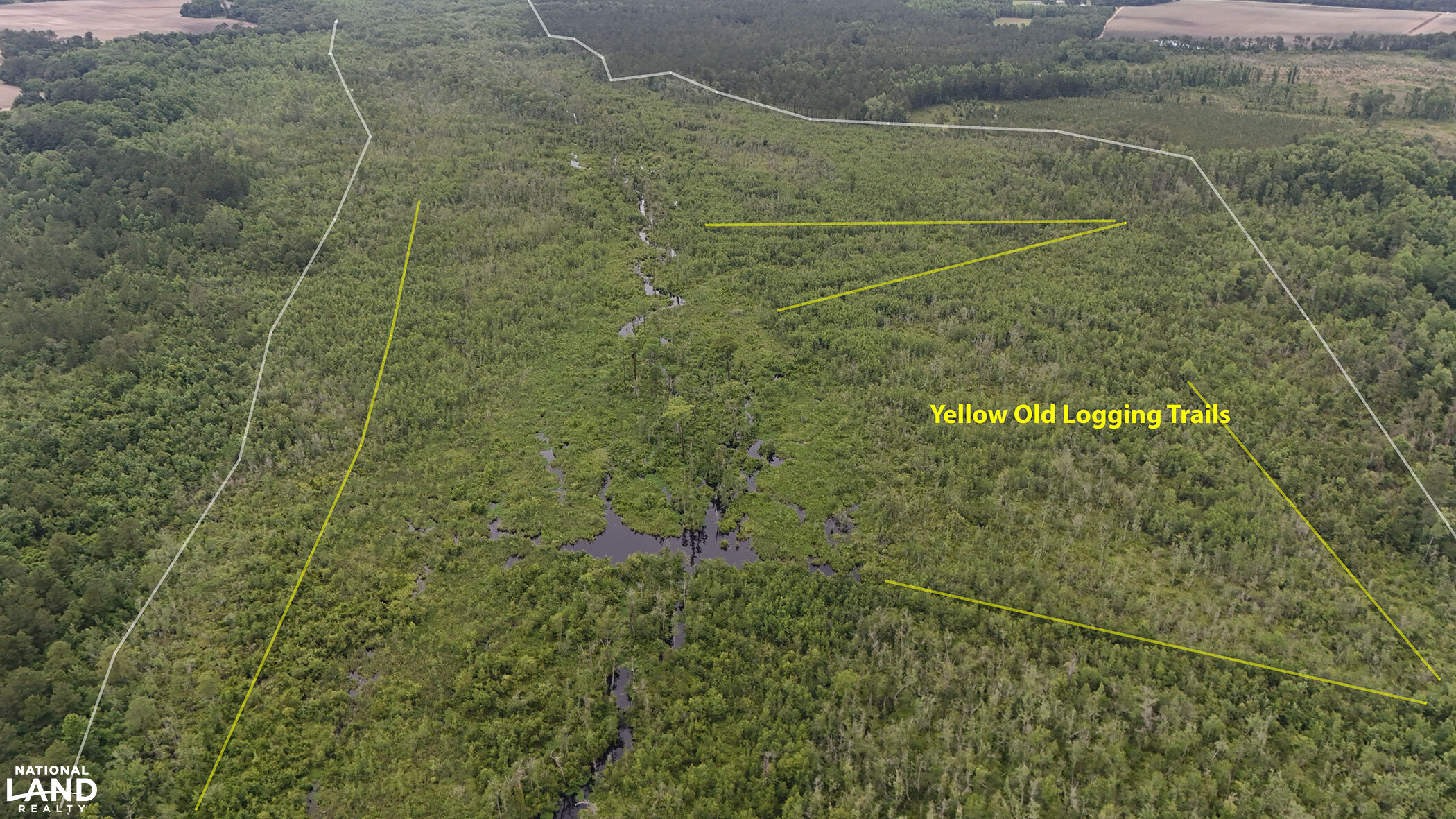
The use of this land is restricted by a Wetland Mitigation Conservation Easement. Available on request. It restricts any future timber harvest. It does allow installation and perpetual maintenance of a 12' wide road along the spine of the property to access all 2.58 miles of the length of the property.
There is a 100' wide proposed gas line easement, an 80' wide utility easement, and an unused railroad track easement that are not regulated by the wetland mitigation easement, allowing outstanding access to the Duck Waters! and opportunities for massive wildlife food plots.
There is a lot at the end of Combine (or combined) dr., a paved road that would accommodate a house, trailer, hunting cabin, etc.
Parcel #/ID
031966544000
Property Highlights
| Hunting, Fishing & Recreation | Fishing, Upland Game, Waterfowl, Turkey, Whitetail Deer, River/Creek/Stream, Bear |
| Timberland Investment | Miscellaneous |
| Homes, Cabins, Acreages & Lots | Vacant Land |
- The order of the pictures and drone 360' are all from South to North in Order. (Starting at the Tailwinds Airport end and heading towards the I-95 end).
- There is a Wetlands Mitigation Easement permanently and perpetually restricting the use of this land. Please inquire and I'll send the document. (no provision to include it in these online listings).
- The waterfowl hunting on this is incredible as generations of waterfowl know these waters to be "safe" haha.
- About half way between Charlotte and N. Myrtle Beach or Topsail Beach or Wilmington.
Estimated Acres:
494 acres pure wildlife breeding ground. Last forested in 1985. 355 ac were clear cut and 139 ac appear to be virgin.
As far as we know, no human has set foot on this since the 1985 timber harvest. (except for me in 2004)
Listing ID#:
3217672
Location
34.834579880075 , -78.938793553934
190 Combine Dr. is the last address on the road ending at the deeded access to this land. Another easy landmark is Tailwinds Airport. The end of that runway is the property.


Land by State
Land Professionals by State
- Alabama
- Arizona
- Arkansas
- California
- Colorado
- Delaware
- Florida
- Georgia
- Idaho
- Illinois
- Indiana
- Iowa
- Kansas
- Kentucky
- Louisiana
- Maryland
- Minnesota
- Mississippi
- Missouri
- Nebraska
- Nevada
- New Mexico
- North Carolina
- North Dakota
- Ohio
- Oklahoma
- Oregon
- Pennsylvania
- South Carolina
- South Dakota
- Tennessee
- Texas
- Utah
- Vermont
- Virginia
- Washington
- West Virginia
- Wisconsin
- Alabama
- Arizona
- Arkansas
- California
- Colorado
- Delaware
- District of Columbia
- Florida
- Georgia
- Idaho
- Illinois
- Indiana
- Iowa
- Kansas
- Kentucky
- Louisiana
- Maryland
- Massachusetts
- Michigan
- Minnesota
- Mississippi
- Missouri
- Montana
- Nebraska
- Nevada
- New Jersey
- New Mexico
- New York
- North Carolina
- North Dakota
- Ohio
- Oklahoma
- Oregon
- Pennsylvania
- South Carolina
- South Dakota
- Tennessee
- Texas
- Utah
- Vermont
- Virginia
- Washington
- West Virginia
- Wisconsin
- Wyoming