Click below to agree to the terms of use.
By clicking the I accept button at the bottom of this page, or by otherwise using the National Land Realty, LLC (“NLR”) website and accessing any content, you agree to be bound by the following terms of use, as updated from time to time (“Terms of Use”).
- Disclaimer about Information Provided. Maps available through this website contain representations of land features compiled from aerial photography, remote sensing technology, recorded deeds and plats, other public records and public data. Users of these maps are hereby notified that the aforementioned public primary information sources should be consulted for verification of the information contained in these maps. These maps are NOT A LAND SURVEY. National Land Realty, LLC, does not warrant the accuracy, reliability or timeliness of any information on this website, including, without limitation, any information relating to any prior sales of any real property, specifically including the purchase price. Portions of such information may be incorrect or not current. Any personal entity that relies on any information obtained from this website does so at his or her own risk. National Land Realty, LLC, hereby disclaims any and all liability arising from the information provided on this website. Any person or entity relying on information from this site does so at their own risk.
- Prohibited Uses. BY USING THE NLR WEBSITE, YOU AGREE NOT TO:
- reproduce, modify, distribute, display or otherwise provide access to, create derivative works from, decompile, disassemble, or reverse engineer any portion of the website or the services provided by the website, except as explicitly permitted under these Terms of Use;
- reproduce, publicly display, or otherwise make accessible on or through any other website, application, or service any reviews, ratings, and/or profile information about real estate, lending, or other professionals, underlying images of or information about real estate listings, or other data or content available through the NLR website, except as explicitly permitted by NLR;
- conduct automated queries (including screen and database scraping, spiders, robots, crawlers, bypassing “captcha” or similar precautions, and any other automated activity with the purpose of obtaining information from the NLR website) on the NLR website;
- Indemnification. You agree to indemnify, defend, and hold harmless NLR, its affiliates, and their respective directors, officers, employees, and agents from any and all claims and demands made by any third party due to or arising out of: (a) your access to or use of the NLR website; (b) your breach of these Terms of Use; (c) your violation of any law or the rights of a third party; (d) any dispute or issue between you and any third party; and (e) your willful misconduct. NLR reserves the right, at its own expense, to assume the exclusive defense and control of any matter otherwise subject to indemnification by you, and in that case, you agree to cooperate with NLR’s defense of that claim.
- No Warranties. THE SERVICES AND INFORMATION PROVIDED ON NLR’S WEBSITE ARE PROVIDED "AS IS," "WITH ALL FAULTS" AND "AS AVAILABLE," AND THE ENTIRE RISK AS TO SATISFACTORY QUALITY, PERFORMANCE, ACCURACY, AND EFFORT IS WITH YOU. TO THE MAXIMUM EXTENT PERMITTED BY APPLICABLE LAW, NLR AND ITS SUPPLIERS MAKE NO REPRESENTATIONS, WARRANTIES OR CONDITIONS, EXPRESS OR IMPLIED. NLR AND ITS SUPPLIERS EXPRESSLY DISCLAIM ANY AND ALL WARRANTIES OR CONDITIONS, EXPRESS, STATUTORY AND IMPLIED. NO ADVICE OR INFORMATION, WHETHER ORAL OR WRITTEN, OBTAINED BY YOU THROUGH THE NLR WEBSITE OR ANY MATERIALS AVAILABLE THROUGH THE NLR WEBSITE WILL CREATE ANY WARRANTY REGARDING ANY NLR ENTITY OR THE NLR WEBSITE THAT IS NOT EXPRESSIVELY STATED IN THESE TERMS OF USE. YOU ASSUME ALL RISK FOR ANY DAMAGE THAT MAY RESULT FROM YOUR USE OF OR ACCESS TO THE NLR WEBSITE, AND ANY MATERIALS, INCLUDING ALL NLR MATERIALS, AVAILABLE THROUGH THE NLR WEBSITE. YOU UNDERSTAND AND AGREE THAT YOUR USE OF THE NLR WEBSITE, AND USE, ACCESS, DOWNLOAD, OR OTHERWISE OBTAINMENT OF MATERIALS THROUGH THE NLR WEBSITE, ARE AT YOUR OWN DISCRETION AND RISK, AND THAT YOU ARE SOLELY RESPONSIBLE FOR ANY DAMAGE TO YOUR PROPERTY (INCLUDING YOUR COMPUTER SYSTEM OR MOBILE DEVICE USED IN CONNECTION WITH THE NLR WEBSITE), OR THE LOSS OF DATA THAT RESULTS FROM THE USE OF THE NLR WEBSITE. SOME JURISDICTIONS MAY PROHIBIT A DISCLAIMER OR WARRANTIES AND YOU MAY HAVE OTHER RIGHTS THAT VARY FROM JURISDICTION TO JURISDICTION.

Why You'll Love It
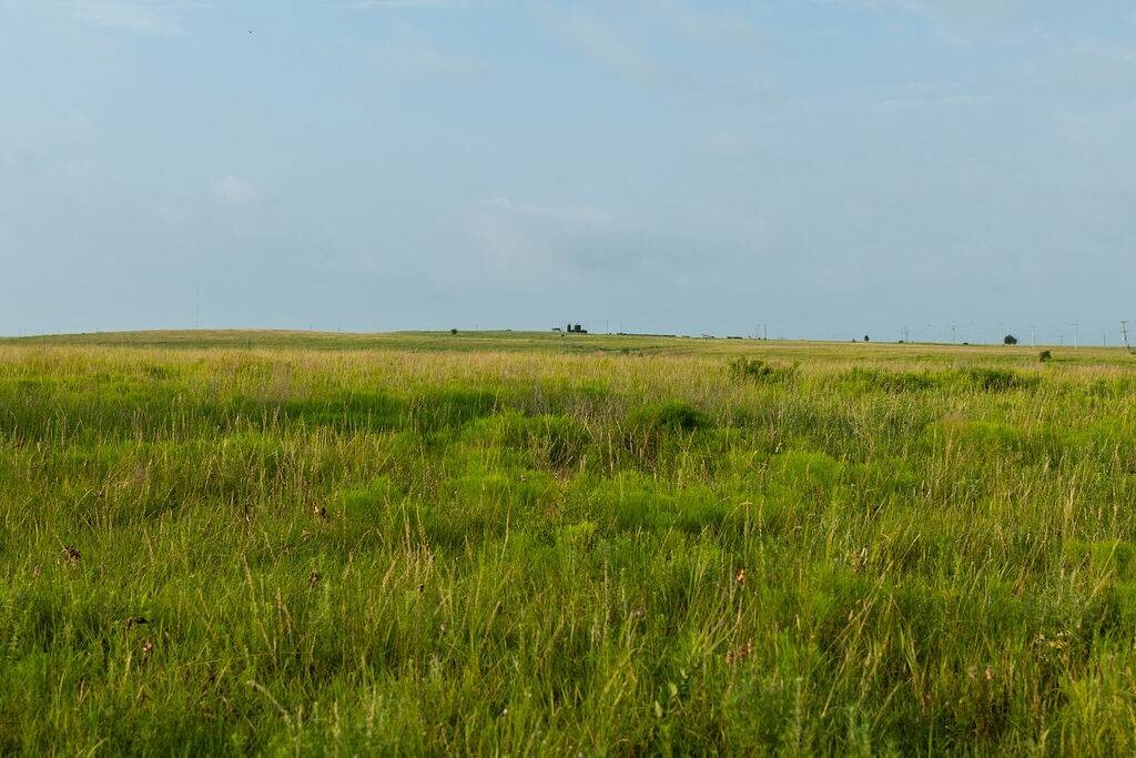
This property was part of the historically significant Tyler Brent Ranch, just on the northeastern edge of Bartlesville. Located minutes from Bartlesville, the entrance is situated on the north side of W 1800 road (Tuxedo Road), just a mile and a half east of the Tuxedo and Bison Road intersection. The west side adjoins the Bison Run Development and several smaller ranchette tracts. This unfenced tract is bisected by a tributary of Coon Creek that flows from the Southeast corner toward the Northwest portion. The elevation changes provide "character" to acreage and provide water development opportunities. PRODUCTION: There are currently active and inactive oil wells on the property; the 80 acres that adjoins Tuxedo Road has qualified for Oklahoma Environmental Resource funds to clean up and remediate damages. The gravel roads on the property are maintained by the oil company and provide some access to the core of the property. A gravel based road also extends north on the east fence line for additional access. SOILS: The soil base of Eram- Verdigris soils in the lower areas is complimented by the Summit and Shidler silty loam soils on the slopes and upland areas. As previously mentioned, the acreage is currently part of a larger pasture with an excellent Tallgrass Prairie forage base. Additional partition fencing would allow rotational grazing to utilize the forage production capabilities of the varying soils. USE: The 360 acres is rated at approximately 10 ac per cow unit on a year-round basis. The tract offers the opportunity for a "ranchette" near Bartlesville with recreation possibilities. In addition to the existing 1.5-acre pond, there is an area to build a substantial dam that would impound a sizeable body of water on the main tributary to Coon Creek. Due to the elevation changes, as mentioned, there are several locations for smaller ponds. UTILITIES: Electricity is available to the development to the west and for the active oil wells. Bartlesville water is available to the intersection of Tuxedo Road and N4013 DR (The southwest corner of the acreage).
Property Highlights
| Farms & Ranches | Ranchland, Range/Pasture |
| Hunting, Fishing & Recreation | River/Creek/Stream, Lake/Pond |
Taxes:
$400
Listing ID#:
2901222
MLS ID#: 11262692
Listing Courtesy of My State MLS.
Cross Timbers Land LLC
Jeff Henry
918-287-1996

My State MLS. © 2025. All rights reserved.
The data relating to real estate on this website comes in part from the IDX of My State MLS, NY State MLS, and State Listings, Inc. Real estate listings held by brokerage firms other than that of the IDX Participant are marked with an IDX logo and the detailed information about including the name of the listing broker. IDX information is provided exclusively for consumers' personal, non-commercial use and may not be used for any purpose other than to identify prospective properties consumers may be interested in purchasing. All information provided is deemed reliable but is not guaranteed and should be independently verified.
This information is being provided for the consumers' personal, non-commercial use and may not be used for any purpose other than to identify prospective properties the consumers may be interested in purchasing. Information deemed reliable but not guaranteed.
Location
36.757387 , -95.87485
Contact
National Land Realty - (580) 207-7026
MLS ID#: 11262692
Listing Courtesy of My State MLS.
Cross Timbers Land LLC
Jeff Henry
918-287-1996
My State MLS. © 2025. All rights reserved.
The data relating to real estate on this website comes in part from the IDX of My State MLS, NY State MLS, and State Listings, Inc. Real estate listings held by brokerage firms other than that of the IDX Participant are marked with an IDX logo and the detailed information about including the name of the listing broker. IDX information is provided exclusively for consumers' personal, non-commercial use and may not be used for any purpose other than to identify prospective properties consumers may be interested in purchasing. All information provided is deemed reliable but is not guaranteed and should be independently verified.
This information is being provided for the consumers' personal, non-commercial use and may not be used for any purpose other than to identify prospective properties the consumers may be interested in purchasing. Information deemed reliable but not guaranteed.


Land by State
Land Professionals by State
- Alabama
- Arizona
- Arkansas
- California
- Colorado
- Delaware
- Florida
- Georgia
- Idaho
- Illinois
- Indiana
- Iowa
- Kansas
- Kentucky
- Louisiana
- Maryland
- Massachusetts
- Minnesota
- Mississippi
- Missouri
- Nebraska
- Nevada
- New Mexico
- North Carolina
- North Dakota
- Ohio
- Oklahoma
- Oregon
- Pennsylvania
- South Carolina
- South Dakota
- Tennessee
- Texas
- Utah
- Vermont
- Virginia
- West Virginia
- Wisconsin
- Alabama
- Arizona
- Arkansas
- California
- Colorado
- Delaware
- District of Columbia
- Florida
- Georgia
- Idaho
- Illinois
- Indiana
- Iowa
- Kansas
- Kentucky
- Louisiana
- Maryland
- Massachusetts
- Michigan
- Minnesota
- Mississippi
- Missouri
- Montana
- Nebraska
- Nevada
- New Jersey
- New Mexico
- New York
- North Carolina
- North Dakota
- Ohio
- Oklahoma
- Oregon
- Pennsylvania
- South Carolina
- South Dakota
- Tennessee
- Texas
- Utah
- Vermont
- Virginia
- Washington
- West Virginia
- Wisconsin
- Wyoming